How to Read a Topographic Map
When you plan a hike, the distance you will walk is only half the story. You’ll also need to know if you’ll have to climb hills and what kind of terrain you’ll be traveling.
Topographic maps are the answer. They show you the shape of the land.
Common road maps simply pinpoint location. They usually are easy to figure out. Topographic maps give a three-dimensional view of the trail, showing hills and valleys, cliffs and clearings.
Learning to read topo maps takes a little practice. Here are a few tips.
UNDERSTANDING A MAP’S SCALE

Scale is the relationship between distance on a map and distance on the ground. It’s a ratio, like 1:24,000 — which means one inch on the map equals 24,000 inches (2,000 feet) on the ground. The larger the second number, the smaller the scale. The smaller the scale, the less detail on the map.
Large-scale maps (typically 1:10,000 or 1:24,000) are best for hiking and canoeing, when you don’t cover much distance. They are easier to read than small-scale maps, but they cover less area. It takes four 1:62,500 maps (where one inch equals about one mile) to cover the same ground as a 1:250,000 map (one inch equals about four miles).
HOW TO READ CONTOUR LINES

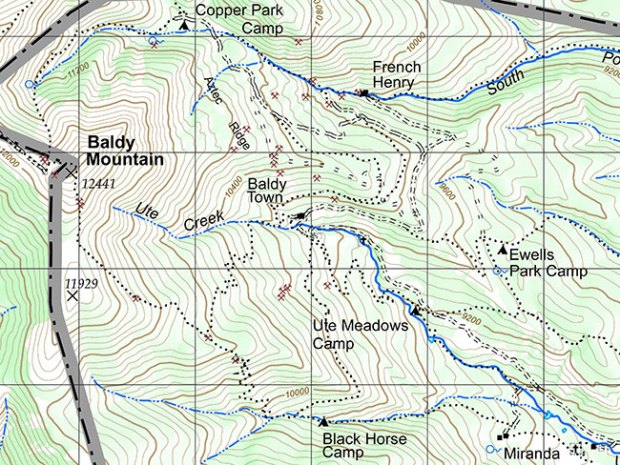
Look at the map of Baldy Mountain at Philmont Scout Ranch. The brown lines are contour lines. They show the shape of the land and its height above sea level. Contour lines look complex, but they’re not — if you know the rules.
Rule 1: Lines connect points of equal elevation. You go uphill or downhill when you travel from one line to another. The closer the lines are to each other, the steeper the hill. Note how close together the contour lines of Baldy Mountain are on the map and how steep it is in the photo.

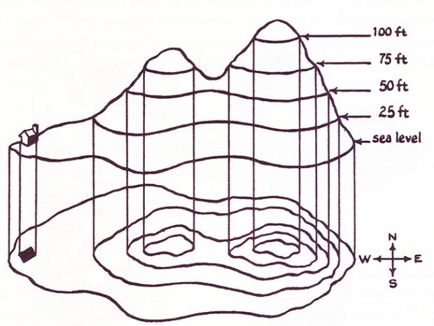
Rule 2: Every contour line forms a circle. Small circles appear near the tops of hills and mountains. Larger circles — which can cover several maps — indicate valleys or prairies.
Rule 3: The contour interval is the vertical distance between contour lines. Its value in feet or meters is given on each map. Every fifth contour line on the map is numbered and is darker.
Rule 4: The closed end (tip of the “V”) of a line points upstream. This also applies to creeks and dry gullies. Check the direction of the V before you canoe or kayak a river. A wrong choice here and you’ll be going against the flow!
MEMORIZE MAP SYMBOLS
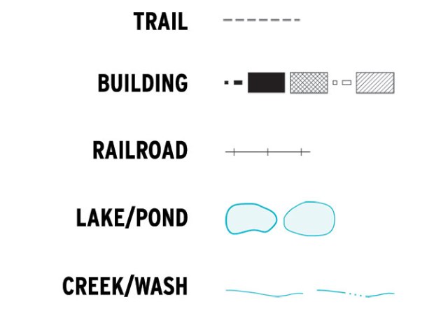
There are more than 100 map symbols. Here are a few common ones.

For more symbols, download the free U.S. Geological Survey booklet “Topographic Map Symbols.”
HOW TO ORIENT YOUR MAP
Now that you can read your map, you’ll need to know where you are.
First, orient the map. Turn it so the magnetic north symbol on the map points in the same direction as your compass needle. What you see on the ground will match your map.
Click here for more compass tips and tricks.
Keep track of time and distance. If you become confused, stop immediately and study your map.
NOW TEST YOUR SKILLS
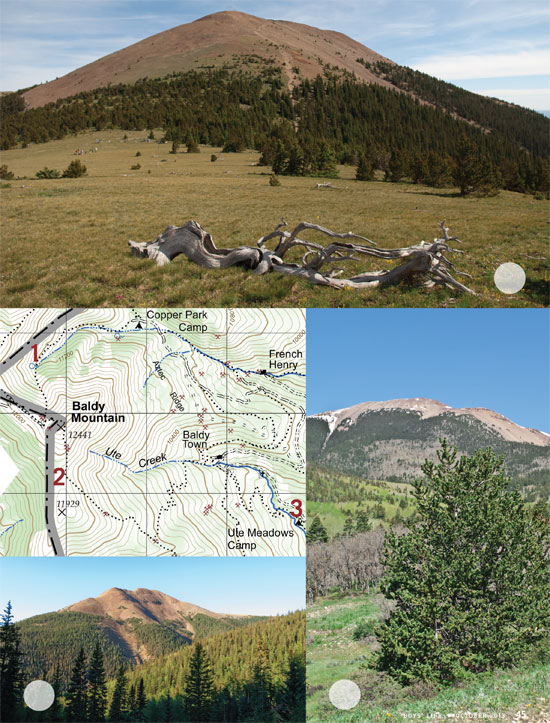
Look at the map below. Match locations 1, 2 and 3 with the correct photo taken from each location. The scale is 1:48,000, and the contour interval is 80 feet.

(Answers: The bottom-left photo is 1; the top photo is 2; the bottom-right is 3.)
The hardest part of this requirement is FINDING a topographical map (especially one that can be printed) to use!
How can I get a topographical map for my grandson that wants to learn how to read maps
Map reading skills were a must when I was at Philmont in 1978. Satellite imagery makes today’s maps so much more accurate.
Awesome maps, well done!
Great! Glad to see use of map reading still part of the program. Glad we are not totally GPS nerds!